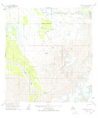
1958 Map of Talkeetna D-5
USGS Topo · Published 1978About this map
The Tonzona River dominates the western lowlands of this Interior Alaska landscape, where the wide glacial drainage meets the foothills of the Alaska Range. To the northeast, the corner of Mt Mc Kinley National Park marks the edge of the protected wilderness, while the surrounding terrain is defined by high alpine features like Heart Mtn and the icy Crevasses found among the peaks. Evidence of early aviation and interior access is preserved through labels for a Landing Strip and a Landing Strip(Aban'd) near Boulder Creek. A Tractor Trail cuts across the center of the map, providing a glimpse into the seasonal transport routes used to navigate this territory. Named landmarks like Brown Bear Basin and Ripsnorter Creek suggest the character of the wildlife and the hydrology of the area during the mid-century mapping period.
Find a feature on this map
20 named features on this map. Tap any name to fly to it.
Don’t see what you’re looking for? This feature index may not catch every label — zoom into the map to look around manually.
Map Details
Editions of this 1958 Talkeetna D-5 Map
3 editions found
Other maps of this area

1950 · Talkeetna
USGS Topo · 1:250,000

1951 · Talkeetna
USGS Topo · 1:250,000

1952 · Mount McKinley
USGS Topo · 1:250,000

1952 · Mount McKinley A-5
USGS Topo · 1:63,360

1953 · Mount McKinley A-4
USGS Topo · 1:63,360

1954 · Mount McKinley A-4
USGS Topo · 1:63,360

1954 · Mount McKinley A-5
USGS Topo · 1:63,360

1958 · Talkeetna D-6
USGS Topo · 1:63,360

1958 · Talkeetna C-6
USGS Topo · 1:63,360

1958 · Talkeetna D-5
USGS Topo · 1:63,360