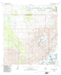
1958 Map of Talkeetna D-5
USGS Topo · Published 1988About this map
Tonzona River headwaters and the braided channels of the Swift Fork define this interior Alaskan landscape during the late 1950s. The map illustrates a critical point of geographic transition where the southern boundary of the Fairbanks Meridian meets the northern boundary of the Seward Meridian. Evidence of aviation history in the bush is preserved through a Landing Strip and a Landing Strip(Aban'd) situated along Boulder Creek. High-altitude terrain is marked by features like Brown Bear Basin and Heart Mtn, while resource extraction is noted by a single Mine located in the southeastern quadrant. This survey reflects the region's character just as the Alaska National Interest Lands Conservation Act would later formalize the surrounding Denali National Park and Denali National Preserve.
Find a feature on this map
20 named features on this map. Tap any name to fly to it.
Don’t see what you’re looking for? This feature index may not catch every label — zoom into the map to look around manually.
Map Details
Editions of this 1958 Talkeetna D-5 Map
3 editions found
Other maps of this area

1950 · Talkeetna
USGS Topo · 1:250,000

1951 · Talkeetna
USGS Topo · 1:250,000

1952 · Mount McKinley
USGS Topo · 1:250,000

1952 · Mount McKinley A-5
USGS Topo · 1:63,360

1953 · Mount McKinley A-4
USGS Topo · 1:63,360

1954 · Mount McKinley A-4
USGS Topo · 1:63,360

1954 · Mount McKinley A-5
USGS Topo · 1:63,360

1958 · Talkeetna D-6
USGS Topo · 1:63,360

1958 · Talkeetna C-6
USGS Topo · 1:63,360

1958 · Talkeetna D-5
USGS Topo · 1:63,360