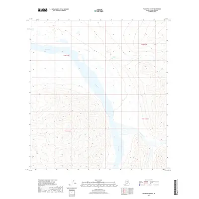
2017 Map of Talkeetna D-5 SW
USGS Topo · Published 2017About this map
Tonzona River dominates the glacial drainage pattern of this interior landscape within the Denali Borough. Flowing through wide valleys defined by the t32n r17w and t31n r17w township boundaries, the river is fed by significant tributaries including Cathedral Cr and Ripsnorter Creek. The mapping reveals a complex topographic environment where steep mountain ridges meet broad alluvial plains. This 2017 survey by the U.S. Geological Survey captures the untouched hydrological network of the region, providing a baseline for geomorphological study in an area where the water bodies themselves are the primary landmarks. The absence of roads or permanent structures underscores the remote nature of this Alaskan wilderness.
Find a feature on this map
7 named features on this map. Tap any name to fly to it.
Don’t see what you’re looking for? This feature index may not catch every label — zoom into the map to look around manually.
Map Details
Editions of this 2017 Talkeetna D-5 SW Map
This is the sole edition of this map. No revisions or reprints were ever made.
Other maps of this area
1950 · Talkeetna
USGS Topo · 1:250,000
1951 · Talkeetna
USGS Topo · 1:250,000
1958 · Talkeetna D-6
USGS Topo · 1:63,360
1958 · Talkeetna C-6
USGS Topo · 1:63,360
1958 · Talkeetna D-5
USGS Topo · 1:63,360
1958 · Talkeetna C-5
USGS Topo · 1:63,360
1958 · Talkeetna
USGS Topo · 1:250,000
1965 · Talkeetna
USGS Topo · 1:250,000
2017 · Talkeetna D-5 SE
USGS Topo · 1:25,000
2017 · Talkeetna D-6 NE
USGS Topo · 1:25,000