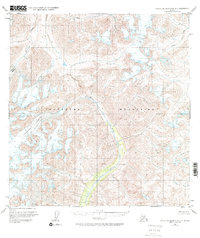
1951 Map of Talkeetna Mountains A-3
USGS Topo · Published 1971About this map
Talkeetna Mountains topography dominates this mid-century survey, revealing a landscape defined by massive ice fields and high-altitude drainage systems. The Talkeetna Glacier and Chickaloon Glacier serve as the primary sources for the area's intricate waterway network, including the southward-flowing Chickaloon River. At the time of this 1949 aerial survey, the region remained largely untouched by permanent settlement, with land lines representing unsurveyed and unmarked locations predetermined by the Bureau of Land Management. The map documents the natural hydrology of the era, from the winding path of Clear Creek in the north to Glass Creek and Caribou Creek in the southeast. A sense of the vast isolation of the territory is captured by features such as Nowhere Creek, located in the northeastern corner of the quadrangle.
Find a feature on this map
8 named features on this map. Tap any name to fly to it.
Don’t see what you’re looking for? This feature index may not catch every label — zoom into the map to look around manually.
Map Details
Editions of this 1951 Talkeetna Mountains A-3 Map
3 editions found
Other maps of this area

1948 · Anchorage D-3
USGS Topo · 1:63,360

1948 · Anchorage D-4
USGS Topo · 1:63,360

1949 · Anchorage D-5
USGS Topo · 1:63,360

1949 · Talkeetna Mountains A-4
USGS Topo · 1:63,360

1950 · Talkeetna Mountains
USGS Topo · 1:250,000

1950 · Talkeetna Mountains B-4
USGS Topo · 1:63,360

1951 · Anchorage
USGS Topo · 1:250,000

1951 · Talkeetna Mountains A-2
USGS Topo · 1:63,360

1951 · Talkeetna Mountains B-3
USGS Topo · 1:63,360

1951 · Talkeetna Mountains A-3
USGS Topo · 1:63,360