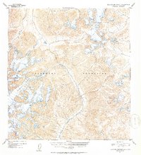
1952 Map of Talkeetna Mountains A-3
USGS Topo · Published 1953About this map
Talkeetna Mountains peaks and glacial systems define this mid-century topographic record of Alaska’s interior. The landscape is a complex network of high-elevation ice and drainage basins, where the massive Talkeetna Glacier feeds the northward-flowing Talkeetna River. To the south, the Chickaloon Glacier serves as the headwaters for the Chickaloon River, which carves a deep path through the center of the quadrangle. This 1952 study shows the natural state of these drainage divides before extensive modern human impact, documenting precise elevations for dozens of unnamed summits alongside established watercourses like Caribou Creek and Clear Creek. The map reflects a period of intensive aerial survey following World War II, providing a primary record of glacial extent and alpine topography in a region defined by its extreme vertical relief.
Find a feature on this map
8 named features on this map. Tap any name to fly to it.
Don’t see what you’re looking for? This feature index may not catch every label — zoom into the map to look around manually.
Map Details
Editions of this 1952 Talkeetna Mountains A-3 Map
2 editions found
Other maps of this area

1948 · Anchorage D-3
USGS Topo · 1:63,360

1948 · Anchorage D-4
USGS Topo · 1:63,360

1949 · Anchorage D-5
USGS Topo · 1:63,360

1949 · Talkeetna Mountains A-4
USGS Topo · 1:63,360

1950 · Talkeetna Mountains
USGS Topo · 1:250,000

1950 · Talkeetna Mountains B-4
USGS Topo · 1:63,360

1951 · Anchorage
USGS Topo · 1:250,000

1951 · Talkeetna Mountains A-2
USGS Topo · 1:63,360

1951 · Talkeetna Mountains B-3
USGS Topo · 1:63,360

1951 · Talkeetna Mountains A-3
USGS Topo · 1:63,360