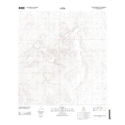
2013 Map of Talkeetna Mountains B-1 SE
USGS Topo · Published 2013About this map
Tyone Cr serves as the primary drainage through this high-elevation Alaskan landscape, where the shifting hydrology of the Matanuska-Susitna Borough is meticulously documented. The creek's meandering course is joined by several smaller tributaries, including Daisy Cr and Grizzly Cr, which flow through the complex relief of the Talkeetna Mountains. In the western reaches, the waters of Tolson Cr and Sellick Cr cut through the high ground, illustrating the natural watershed patterns of this unpopulated region. The map captures a wilderness devoid of modern structures or road networks, focusing instead on the precise topography and the glacial or snow-melt-fed waters of Fourth of July Cr and the isolated S Lake. This 2013 survey provides an essential baseline for geologists and environmental researchers tracking change in these subarctic highlands.
Find a feature on this map
11 named features on this map. Tap any name to fly to it.
Don’t see what you’re looking for? This feature index may not catch every label — zoom into the map to look around manually.
Map Details
Editions of this 2013 Talkeetna Mountains B-1 SE Map
This is the sole edition of this map. No revisions or reprints were ever made.
Other maps of this area
1949 · Talkeetna Mountains A-1
USGS Topo · 1:63,360
1949 · Gulkana A-6
USGS Topo · 1:63,360
1950 · Talkeetna Mountains
USGS Topo · 1:250,000
1950 · Gulkana B-6
USGS Topo · 1:63,360
1951 · Gulkana
USGS Topo · 1:250,000
1951 · Talkeetna Mountains B-1
USGS Topo · 1:63,360
1952 · Gulkana A-6
USGS Topo · 1:63,360
1952 · Talkeetna Mountains A-1
USGS Topo · 1:63,360
1952 · Gulkana B-6
USGS Topo · 1:63,360
1952 · Talkeetna Mountains B-1
USGS Topo · 1:63,360