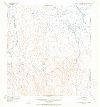
1952 Map of Talkeetna Mountains B-1
USGS Topo · Published 1953About this map
The Oshetna River and its numerous glacial tributaries dominate this 1952 topographic study of the central Talkeetna Mountains. The landscape is defined by complex drainage patterns, where the Little Oshetna River and Sanona Creek carve through the high elevations of south-central Alaska. This survey reflects a period of intensive aerial mapping by the Geological Survey, using 1949 photography to chart the drainage basins of the Tyone Creek and Daisy Creek systems. The lack of man-made structures or roads emphasizes the isolation of this region shortly after the war, where travel was dictated by the watercourses like Fourth of July Creek and Settler Creek. Local history and geography enthusiasts can trace the intricate network of named streams, including Red Creek, Yacko Creek, and Walker Creek, which illustrate the hydrological character of the Matanuska-Susitna area before more modern development reached its deeper interior.
Find a feature on this map
11 named features on this map. Tap any name to fly to it.
Don’t see what you’re looking for? This feature index may not catch every label — zoom into the map to look around manually.
Map Details
Editions of this 1952 Talkeetna Mountains B-1 Map
2 editions found
Other maps of this area

1949 · Talkeetna Mountains A-1
USGS Topo · 1:63,360

1949 · Gulkana A-6
USGS Topo · 1:63,360

1950 · Talkeetna Mountains
USGS Topo · 1:250,000

1950 · Gulkana B-6
USGS Topo · 1:63,360

1951 · Gulkana
USGS Topo · 1:250,000

1951 · Talkeetna Mountains B-1
USGS Topo · 1:63,360

1951 · Talkeetna Mountains A-2
USGS Topo · 1:63,360

1951 · Talkeetna Mountains C-2
USGS Topo · 1:63,360

1951 · Talkeetna Mountains B-2
USGS Topo · 1:63,360

1951 · Talkeetna Mountains C-1
USGS Topo · 1:63,360