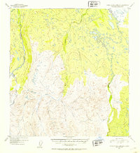
1952 Map of Talkeetna Mountains B-1
USGS Topo · Published 1953About this map
The Oshetna River and its major tributary, the Little Oshetna River, dominate the western portion of this mid-century Alaskan interior landscape. This terrain is defined by a dense network of high-altitude waterways, including Tyone Creek and Sanona Creek, which drain the eastern and central slopes. The absence of roads or established settlements in this 1952 record highlights the wilderness character of the region during the early post-war era, before major modern infrastructure arrived.
Find a feature on this map
15 named features on this map. Tap any name to fly to it.
Don’t see what you’re looking for? This feature index may not catch every label — zoom into the map to look around manually.
Map Details
Editions of this 1952 Talkeetna Mountains B-1 Map
2 editions found
Other maps of this area

1949 · Talkeetna Mountains A-1
USGS Topo · 1:63,360

1949 · Gulkana A-6
USGS Topo · 1:63,360

1950 · Talkeetna Mountains
USGS Topo · 1:250,000

1950 · Gulkana B-6
USGS Topo · 1:63,360

1951 · Gulkana
USGS Topo · 1:250,000

1951 · Talkeetna Mountains B-1
USGS Topo · 1:63,360

1951 · Talkeetna Mountains A-2
USGS Topo · 1:63,360

1951 · Talkeetna Mountains C-2
USGS Topo · 1:63,360

1951 · Talkeetna Mountains B-2
USGS Topo · 1:63,360

1951 · Talkeetna Mountains C-1
USGS Topo · 1:63,360