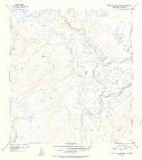
1952 Map of Talkeetna Mountains D-1
USGS Topo · Published 1953About this map
The Susitna River winds through this high-altitude wilderness, joined by the Maclaren River and several major tributaries in a complex network of glacial drainage. Mapped from 1949 aerial photography, the landscape is defined by its extreme isolation and the presence of prominent survey markers like Vabm 3716 Sumaridason and Vabm 3299 Coal. The terrain is characterized by numerous small lakes and ponds scattered across the basins of Clearwater Creek and Coal Creek, reflecting the post-glacial geography of the Alaska-Third Judicial Division before modern infrastructure reached this interior region.
Find a feature on this map
6 named features on this map. Tap any name to fly to it.
Don’t see what you’re looking for? This feature index may not catch every label — zoom into the map to look around manually.
Map Details
Editions of this 1952 Talkeetna Mountains D-1 Map
2 editions found
Other maps of this area

1949 · Healy A-1
USGS Topo · 1:63,360

1950 · Talkeetna Mountains
USGS Topo · 1:250,000

1950 · Mount Hayes
USGS Topo · 1:250,000

1950 · Mount Hayes A-6
USGS Topo · 1:63,360

1951 · Healy
USGS Topo · 1:250,000

1951 · Gulkana
USGS Topo · 1:250,000

1951 · Mount Hayes
USGS Topo · 1:250,000

1951 · Gulkana D-6
USGS Topo · 1:63,360

1951 · Talkeetna Mountains C-2
USGS Topo · 1:63,360

1951 · Talkeetna Mountains D-2
USGS Topo · 1:63,360