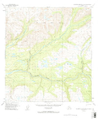
1950 Map of Talkeetna Mountains D-5
USGS Topo · Published 1971About this map
The Susitna River carves a dramatic path through this remote Alaskan landscape, defining the central geography of the quadrangle. In 1950, this area remained largely unsettled, characterized by the convergence of the Seward Meridian and Fairbanks Meridian, which serve as critical reference points for the vast unsurveyed interior. The most prominent terrain feature is the Devils Canyon, a narrow gorge where the river accelerates through steep elevation changes. Historical transit through the area is represented by the Winter Trail, a seasonal route that provided access before the development of modern roads. Smaller waterways like Indian River and Devil Creek flow through the interior, while the VABM 4741 Portage benchmark indicates a high point overlooking Portage Creek. This map captures a moment when the territory was mapped primarily from aerial photographs, preserving the original nomenclature of the wilderness.
Find a feature on this map
12 named features on this map. Tap any name to fly to it.
Don’t see what you’re looking for? This feature index may not catch every label — zoom into the map to look around manually.
Map Details
Editions of this 1950 Talkeetna Mountains D-5 Map
3 editions found
Other maps of this area

1949 · Talkeetna Mountains D-6
USGS Topo · 1:63,360

1949 · Talkeetna Mountains C-6
USGS Topo · 1:63,360

1949 · Healy A-6
USGS Topo · 1:63,360

1950 · Talkeetna Mountains
USGS Topo · 1:250,000

1950 · Talkeetna Mountains D-5
USGS Topo · 1:63,360

1950 · Healy A-4
USGS Topo · 1:63,360

1950 · Healy A-5
USGS Topo · 1:63,360

1950 · Talkeetna Mountains C-5
USGS Topo · 1:63,360

1951 · Healy
USGS Topo · 1:250,000

1951 · Talkeetna Mountains D-5
USGS Topo · 1:63,360