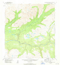
1950 Map of Talkeetna Mountains D-5
USGS Topo · Published 1971About this map
Susitna River watercourses dominate this 1950s terrain, where the river carves through the dramatic Devils Canyon. The landscape is a study in remote Alaskan infrastructure of the era, marked by a seasonal Winter Trail and a handful of isolated Cabin and Cabins sites that likely served as essential shelters for travelers and trappers. This map is particularly notable for its depiction of major drainage systems, including Indian River, Portage Creek, and Devil Creek, all feeding into the primary Susitna artery.
Find a feature on this map
13 named features on this map. Tap any name to fly to it.
Don’t see what you’re looking for? This feature index may not catch every label — zoom into the map to look around manually.
Map Details
Editions of this 1950 Talkeetna Mountains D-5 Map
3 editions found
Other maps of this area

1949 · Talkeetna Mountains D-6
USGS Topo · 1:63,360

1949 · Talkeetna Mountains C-6
USGS Topo · 1:63,360

1949 · Healy A-6
USGS Topo · 1:63,360

1950 · Talkeetna Mountains
USGS Topo · 1:250,000

1950 · Talkeetna Mountains D-5
USGS Topo · 1:63,360

1950 · Healy A-4
USGS Topo · 1:63,360

1950 · Healy A-5
USGS Topo · 1:63,360

1950 · Talkeetna Mountains C-5
USGS Topo · 1:63,360

1951 · Healy
USGS Topo · 1:250,000

1951 · Talkeetna Mountains D-5
USGS Topo · 1:63,360