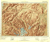
1950 Map of Talkeetna Mountains
USGS Topo · Published 1950About this map
The Alaska Railroad corridor defines the western edge of this 1950 reconnaissance, tracing a narrow path of industry through the high peaks of the Talkeetna Mountains. Small rail-dependent settlements like Hurricane, Sherman, and Gold Creek dot the line where it follows the Chulitna River and Susitna River valleys. Compiled from Trimetrogon photography and early field surveys dating back to 1898, the map illustrates the complex drainage patterns of the interior before modern development. Notable glacial features including the Eldridge Glacier are documented alongside high-altitude landmarks such as Mt Watana and the Tsisi Terrace. The eastern portion of the sheet opens into a network of tributaries including the Oshetna River and Tyone River, indicating the importance of these waterways for navigation and early exploration within the Third Judicial Division.
Find a feature on this map
70 named features on this map. Tap any name to fly to it.
Don’t see what you’re looking for? This feature index may not catch every label — zoom into the map to look around manually.
Map Details
Editions of this 1950 Talkeetna Mountains Map
2 editions found

Other maps of this area

1948 · Anchorage D-3
USGS Topo · 1:63,360

1948 · Anchorage D-2
USGS Topo · 1:63,360

1948 · Anchorage D-4
USGS Topo · 1:63,360

1948 · Anchorage D-1
USGS Topo · 1:63,360

1949 · Tyonek
USGS Topo · 1:250,000

1949 · Talkeetna Mountains D-6
USGS Topo · 1:63,360

1949 · Anchorage D-5
USGS Topo · 1:63,360

1949 · Anchorage D-7
USGS Topo · 1:63,360

1949 · Talkeetna Mountains B-6
USGS Topo · 1:63,360

1949 · Talkeetna Mountains A-1
USGS Topo · 1:63,360