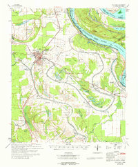
1965 Map of Talla Bena
USGS Topo · Published 1965About this map
Mississippi River meanders define this boundary between Louisiana and Mississippi, where the Marshall Cut-Off (1934) and Millikens Bend illustrate the shifting hydrology of the Delta. The regional hub of Tallulah stands as a focal point for transportation, served by the Illinois Central railroad and a grid of rural routes connecting outlying farming communities. The landscape is dense with community landmarks that reflect the social fabric of the mid-1960s, including numerous local congregations such as Morning Star Ch, Jerusalem Ch, and Mt Moriah Ch No 1. Beyond the larger settlements like Mound and Thomastown, the map documents smaller sites like Solomon Temple and the Red Beard Landing Strip, alongside several cemeteries and schools such as Wright Sch that served the dispersed agricultural population across the alluvial plain.
Find a feature on this map
86 named features on this map. Tap any name to fly to it.
Don’t see what you’re looking for? This feature index may not catch every label — zoom into the map to look around manually.
Map Details
Editions of this 1965 Talla Bena Map
3 editions found
Other maps of this area

1909 · Millikens Bend
USGS Topo · 1:24,000

1909 · Tallulah
USGS Topo · 1:24,000

1909 · Mound
USGS Topo · 1:24,000

1910 · Mound
USGS Topo · 1:31,680

1918 · Vicksburg
USGS Topo · 1:62,500

1935 · Waverly
USGS Topo · 1:62,500

1935 · Shackleford Lake
USGS Topo · 1:62,500

1939 · Onward
USGS Topo · 1:62,500

1939 · Talla Bena
USGS Topo · 1:62,500

1939 · Yokena
USGS Topo · 1:62,500