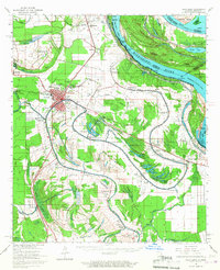
1965 Map of Talla Bena
USGS Topo · Published 1967About this map
Tallulah serves as a central hub of development in this mid-1960s landscape, where the Missouri Pacific and Illinois Central railroads intersect amidst a complex network of bayous and oxbow lakes. The transition from river-dependent landings like Millikens Bend Ldg and Ashly Ldg to land-based infrastructure is evident, with Marlin Airport and Scott Airport established near the town center. The rural landscape is densely punctuated by country churches and community markers, including Jerusalem Ch, Galilee Ch, and the Solomon Temple near Roundaway Bayou.
Find a feature on this map
103 named features on this map. Tap any name to fly to it.
Don’t see what you’re looking for? This feature index may not catch every label — zoom into the map to look around manually.
Map Details
Editions of this 1965 Talla Bena Map
3 editions found
Other maps of this area

1909 · Millikens Bend
USGS Topo · 1:24,000

1909 · Tallulah
USGS Topo · 1:24,000

1909 · Mound
USGS Topo · 1:24,000

1910 · Mound
USGS Topo · 1:31,680

1918 · Vicksburg
USGS Topo · 1:62,500

1935 · Waverly
USGS Topo · 1:62,500

1935 · Shackleford Lake
USGS Topo · 1:62,500

1939 · Onward
USGS Topo · 1:62,500

1939 · Talla Bena
USGS Topo · 1:62,500

1939 · Yokena
USGS Topo · 1:62,500