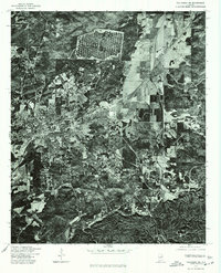
1975 Map of Talladega NE
USGS Topo · Published 1977About this map
Talladega serves as the central hub of this orthophotoquad, showing the city's mid-1970s footprint as captured through high-altitude aerial photography. The imagery reveals the dense grid of the urban center contrasting with the surrounding industrial and residential outskirts, including the settlement of Bemiston to the southwest. This specific format, produced in cooperation with the Soil Conservation Service, emphasizes the actual land use and vegetation patterns of the era rather than stylized topographic lines. To the southeast, the smaller community of Waldo sits amidst a mosaic of cleared fields and timbered tracts, illustrating the rural-urban interface typical of Talladega County during this period. The orthophoto's detail allows for a precise look at the road networks and railway corridors that shaped local commerce and movement in the years following the mid-century industrial peak.
Find a feature on this map
3 named features on this map. Tap any name to fly to it.
Don’t see what you’re looking for? This feature index may not catch every label — zoom into the map to look around manually.
Map Details
Editions of this 1975 Talladega NE Map
This is the sole edition of this map. No revisions or reprints were ever made.
Other maps of this area

1889 · Springville
USGS Topo · 1:125,000

1890 · Talladega
USGS Topo · 1:125,000

1891 · Ashland
USGS Topo · 1:125,000

1892 · Springville
USGS Topo · 1:125,000

1892 · Talladega
USGS Topo · 1:125,000

1900 · Anniston
USGS Topo · 1:125,000

1943 · Talladega
USGS Topo · 1:62,500

1946 · Talladega
USGS Topo · 1:62,500

1947 · Eastaboga
USGS Topo · 1:24,000

1947 · Ragland
USGS Topo · 1:62,500