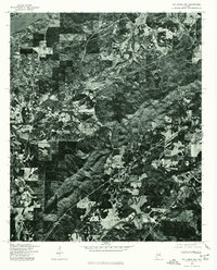
1975 Map of Talladega NW
USGS Topo · Published 1977About this map
The Coosa River defines the northwestern boundary of this mid-1970s orthophoto, where the landscape transitions from riverine lowlands to the more industrial and agricultural sectors of Talladega County. Captured by the Soil Conservation Service through high-altitude aerial photography, the imagery reveals a complex arrangement of timbered hills and clearing patterns that speak to the region's mid-century land use. The industrial settlement of Bemiston is visible on the eastern edge, showing the organized street patterns and facility footprints of a community built around manufacturing and textile production during this era. This specific survey provides an exceptionally clear view of the road network and field boundaries as they existed before late-twentieth-century residential expansion, preserving the exact layout of the local timber and industrial economy.
Find a feature on this map
2 named features on this map. Tap any name to fly to it.
Don’t see what you’re looking for? This feature index may not catch every label — zoom into the map to look around manually.
Map Details
Editions of this 1975 Talladega NW Map
This is the sole edition of this map. No revisions or reprints were ever made.
Other maps of this area

1889 · Springville
USGS Topo · 1:125,000

1890 · Talladega
USGS Topo · 1:125,000

1892 · Springville
USGS Topo · 1:125,000

1892 · Talladega
USGS Topo · 1:125,000

1943 · Talladega
USGS Topo · 1:62,500

1946 · Talladega
USGS Topo · 1:62,500

1947 · Eastaboga
USGS Topo · 1:24,000

1947 · Ragland
USGS Topo · 1:62,500

1947 · Riverside
USGS Topo · 1:24,000

1951 · Laniers
USGS Topo · 1:24,000