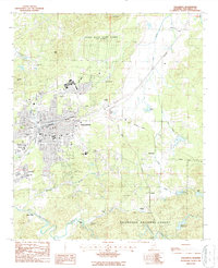
1987 Map of Talladega
USGS Topo · Published 1987About this map
Talladega serves as the central hub of this north-central Alabama landscape, established as a prominent educational and regional center. The map details the campus of Talladega College and specialized institutions like the Helen Keller Sch of Ala and E H Gentry Tech Sch. To the north, the sprawling Coosa River Depot Annex (US Army) occupies a significant footprint, illustrating the area's mid-century military importance.
Find a feature on this map
56 named features on this map. Tap any name to fly to it.
Don’t see what you’re looking for? This feature index may not catch every label — zoom into the map to look around manually.
Map Details
Editions of this 1987 Talladega Map
This is the sole edition of this map. No revisions or reprints were ever made.
Other maps of this area

1889 · Springville
USGS Topo · 1:125,000

1890 · Talladega
USGS Topo · 1:125,000

1891 · Ashland
USGS Topo · 1:125,000

1892 · Springville
USGS Topo · 1:125,000

1892 · Talladega
USGS Topo · 1:125,000

1900 · Anniston
USGS Topo · 1:125,000

1943 · Talladega
USGS Topo · 1:62,500

1946 · Talladega
USGS Topo · 1:62,500

1947 · Eastaboga
USGS Topo · 1:24,000

1947 · Ragland
USGS Topo · 1:62,500