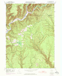
1946 Map of Tamarack
USGS Topo · Published 1972About this map
Kettle Creek carves a deep valley through the northern reaches of this terrain, marking the boundary where Potter Co meets Clinton Co. The settlement of Cross Fork serves as a focal point in the north, while the southern landscape is dominated by the sprawling Tamarack Swamp and the elevated Tamarack Lookout Tower. This high-relief topography, defined by ridges like Big Ridge and summits such as Dykes Peak, illustrates the rugged drainage patterns of north-central Pennsylvania. Geographers and local historians will note the concentration of family-named landmarks and hollows, including Clarey Run and Stewarts Run, which indicate the long-standing ties between small mountain communities and the surrounding watersheds. The presence of Laurel Hill Cem near the river bend provides a specific touchstone for genealogical research in this isolated upland region.
Find a feature on this map
36 named features on this map. Tap any name to fly to it.
Don’t see what you’re looking for? This feature index may not catch every label — zoom into the map to look around manually.
Map Details
Editions of this 1946 Tamarack Map
4 editions found
Other maps of this area

1943 · Hyner
USGS Topo · 1:62,500

1946 · Young Womans Creek
USGS Topo · 1:24,000

1946 · Renovo East
USGS Topo · 1:62,500

1946 · Renovo West
USGS Topo · 1:62,500

1946 · Hammersley Fork
USGS Topo · 1:24,000

1946 · Keating
USGS Topo · 1:24,000

1946 · Tamarack
USGS Topo · 1:24,000

1946 · Renovo East
USGS Topo · 1:24,000

1946 · Renovo West
USGS Topo · 1:24,000

1947 · Conrad
USGS Topo · 1:62,500
Featured Places
- Leidy Township, PA
- Wharton Township, PA
- Tamarack, Leidy Township
- Cross Fork, Stewardson Township
- Stewardson Township, PA