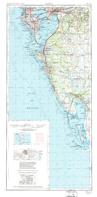
1956 Map of Tampa
USGS Topo · Published 1987About this map
St Petersburg and Tampa anchor a coastline defined by intricate barrier islands and expanding mid-century infrastructure. The mid-1950s landscape, updated in the early 1970s, shows the primary transit links across Tampa Bay, including the Gandy Bridge and the Howard Frankland Bridge. Military operations are centered at Mac Dill AFB on the Interbay Peninsula, while the Seaboard Coast Line railroad facilitates inland commerce toward Brandon and Wimauma.
Find a feature on this map
156 named features on this map. Tap any name to fly to it.
Don’t see what you’re looking for? This feature index may not catch every label — zoom into the map to look around manually.
Map Details
Editions of this 1956 Tampa Map
2 editions found

Other maps of this area

1921 · Sand Key
USGS Topo · 1:62,500

1921 · Tampa
USGS Topo · 1:62,500

1921 · Fort De Soto
USGS Topo · 1:62,500

1921 · St Petersburg
USGS Topo · 1:62,500

1942 · Cockroach Bay
USGS Topo · 1:31,680

1943 · St Petersburg
USGS Topo · 1:31,680

1943 · Gandy Bridge
USGS Topo · 1:31,680

1943 · Pass-A-Grille
USGS Topo · 1:31,680
1943 · Bay Pines
USGS Topo · 1:31,680

1943 · Safety Harbor
USGS Topo · 1:31,680