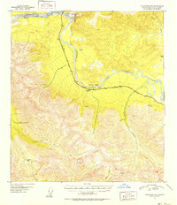
1951 Map of Tanacross B-6
USGS Topo · Published 1952About this map
The Alaska Range dominates the southern half of this landscape, its steep contours rising toward high points like VABM 6970 Shin and Tushtena Pass. To the north, the terrain gives way to the broad valley carved by the Tanana River and its major tributaries, including the Robertson River and Yerrick Creek. This 1948 aerial survey captures a critical era of post-war infrastructure development in the interior, centered on the strategic corridor of the Alaska Highway. Running parallel to the river, the highway is joined by the Alaska Pipe Line, marking the intersection of transportation and resource logistics. Landmarks along this route, such as Cathedral Rapids and the Cathedral Bluffs, provide specific navigational anchors in an otherwise massive wilderness. Numerous bench marks, including BM 1686 Yarich, suggest the intensive surveying required to maintain these vital inland arteries.
Find a feature on this map
30 named features on this map. Tap any name to fly to it.
Don’t see what you’re looking for? This feature index may not catch every label — zoom into the map to look around manually.
Map Details
Editions of this 1951 Tanacross B-6 Map
2 editions found

Other maps of this area

1948 · Tanacross B-5
USGS Topo · 1:63,360

1948 · Tanacross A-6
USGS Topo · 1:63,360

1948 · Tanacross A-5
USGS Topo · 1:63,360

1949 · Tanacross
USGS Topo · 1:250,000

1949 · Tanacross A-5
USGS Topo · 1:63,360

1949 · Tanacross B-6
USGS Topo · 1:63,360

1949 · Mt. Hayes A-1
USGS Topo · 1:63,360

1950 · Tanacross
USGS Topo · 1:250,000

1950 · Mount Hayes
USGS Topo · 1:250,000

1951 · Mount Hayes
USGS Topo · 1:250,000