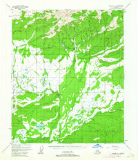
1952 Map of Tanana A-1
USGS Topo · Published 1964About this map
Eureka and the nearby settlement of Glen anchor the central hills of this interior Alaska territory during the early 1950s. The landscape is defined by the resource-driven infrastructure of the era, most notably the extensive hydraulic mining networks including the Thanksgiving Ditch, Pioneer Ditch, and several other unnamed channels cut through the drainages of Minook Creek and Hutlinana Creek. These ditches, paired with a primitive Tractor Trail and a local Landing Strip, trace the physical efforts to move water and equipment across the complex terrain surrounding Eureka Dome. To the south, the topography transitions from the high points of Bean Ridge and the Dugan Hills into the marshy lowlands of the Baker Creek basin. This area is punctuated by Baker Lake and numerous seasonal sloughs, highlighting the contrast between the high-ground mining operations and the broad, water-logged valleys of the Yukon-Koyukuk region.
Find a feature on this map
45 named features on this map. Tap any name to fly to it.
Don’t see what you’re looking for? This feature index may not catch every label — zoom into the map to look around manually.
Map Details
Editions of this 1952 Tanana A-1 Map
3 editions found
Other maps of this area

1945 · Livengood
USGS Topo · 1:250,000

1948 · Kantishna River
USGS Topo · 1:250,000

1950 · Fairbanks
USGS Topo · 1:250,000

1951 · Kantishna River
USGS Topo · 1:250,000

1951 · Fairbanks
USGS Topo · 1:250,000

1951 · Tanana
USGS Topo · 1:250,000

1951 · Livengood
USGS Topo · 1:250,000

1952 · Tanana A-1
USGS Topo · 1:63,360

1952 · Livengood A-6
USGS Topo · 1:63,360

1952 · Tanana A-2
USGS Topo · 1:63,360