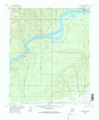
1956 Map of Tanana B-2
USGS Topo · Published 1971About this map
The Yukon River cuts a wide path through this interior Alaska landscape, creating distinctive landmarks like Twelvemile Island and Garnet Island. Surveyed in the mid-1950s, the map reveals a remote wilderness where human presence is marked only by isolated Cabin and Cabins sites along the riverbanks and the base of Raven Ridge. The drainage system is intricate, with Moose Creek, Garnet Creek, and Fish Creek feeding into the main channel from the surrounding highlands.
Find a feature on this map
19 named features on this map. Tap any name to fly to it.
Don’t see what you’re looking for? This feature index may not catch every label — zoom into the map to look around manually.
Map Details
Editions of this 1956 Tanana B-2 Map
3 editions found
Other maps of this area

1951 · Tanana
USGS Topo · 1:250,000

1952 · Tanana A-1
USGS Topo · 1:63,360

1952 · Tanana A-3
USGS Topo · 1:63,360

1952 · Tanana A-2
USGS Topo · 1:63,360

1953 · Tanana A-2
USGS Topo · 1:63,360

1953 · Tanana A-3
USGS Topo · 1:63,360

1956 · Tanana B-1
USGS Topo · 1:63,360

1956 · Tanana C-1
USGS Topo · 1:63,360

1956 · Tanana B-2
USGS Topo · 1:63,360

1956 · Tanana C-3
USGS Topo · 1:63,360