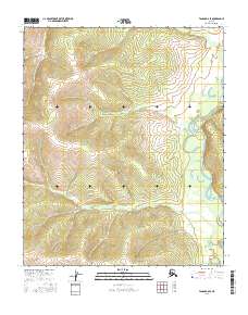
2016 Map of Tanana B-6 SE
USGS Topo · Published 2016About this map
Tozitna River meanders through the eastern edge of this landscape, its winding channel defining the drainage patterns south of Tozimoran Cr. This 2016 survey captures a largely untouched wilderness within the Yukon-Koyukuk region, where elevation rises toward the southwestern corner at Gold Hill. The map detail follows the convergence of several smaller waterways, including the headwaters and tributaries of Bluebell Cr and Slate Cr, providing a precise look at the hydrography and terrain before these waters join the larger river systems of the Alaska interior. The cartography emphasizes the natural contours and township boundaries of T6N and T5N, offering a clear record of the region's physical geography as it existed in the mid-2010s.
Find a feature on this map
9 named features on this map. Tap any name to fly to it.
Don’t see what you’re looking for? This feature index may not catch every label — zoom into the map to look around manually.
Map Details
Editions of this 2016 Tanana B-6 SE Map
This is the sole edition of this map. No revisions or reprints were ever made.
Other maps of this area

1951 · Tanana
USGS Topo · 1:250,000

1952 · Tanana A-6
USGS Topo · 1:63,360

1952 · Tanana A-5
USGS Topo · 1:63,360

1953 · Tanana A-5
USGS Topo · 1:63,360

1956 · Tanana B-5
USGS Topo · 1:63,360

1956 · Tanana B-6
USGS Topo · 1:63,360

1956 · Tanana
USGS Topo · 1:250,000

1960 · Tanana
USGS Topo · 1:250,000
2016 · Tanana B-6 SW
USGS Topo · 1:25,000
2016 · Tanana B-5 SW
USGS Topo · 1:25,000