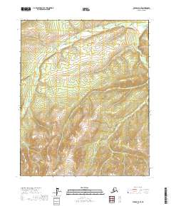
2017 Map of Tanana D-2 SE
USGS Topo · Published 2017About this map
The Big Salt River carves through this northern Alaskan landscape, forming the primary drainage for the surrounding highlands. This 2017 survey by the U.S. Geological Survey illustrates the complex topography of the Yukon-Koyukuk Census Area, where numerous tributaries feed into the larger river system. Among these are Dreamland Cr, which flows through the eastern sectors, and Asbestos Cr to the south. The absence of roads or established settlements on this sheet highlights the wilderness character of the region, defined primarily by its drainage patterns and township boundaries like t12n r15w. Local geography is further detailed by smaller watercourses such as Hulu Cr, providing a clear record of the watershed before any modern development or infrastructure was introduced to these specific coordinates.
Find a feature on this map
8 named features on this map. Tap any name to fly to it.
Don’t see what you’re looking for? This feature index may not catch every label — zoom into the map to look around manually.
Map Details
Editions of this 2017 Tanana D-2 SE Map
This is the sole edition of this map. No revisions or reprints were ever made.
Other maps of this area

1951 · Tanana
USGS Topo · 1:250,000

1956 · Tanana C-1
USGS Topo · 1:63,360

1956 · Tanana D-2
USGS Topo · 1:63,360

1956 · Tanana C-2
USGS Topo · 1:63,360

1956 · Tanana D-1
USGS Topo · 1:63,360

1956 · Tanana
USGS Topo · 1:250,000

1960 · Tanana
USGS Topo · 1:250,000
2017 · Tanana D-2 SW
USGS Topo · 1:25,000
2017 · Tanana C-2 NW
USGS Topo · 1:25,000
2017 · Tanana D-2 NW
USGS Topo · 1:25,000