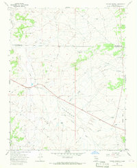
1966 Map of Tancosa Windmill
USGS Topo · Published 1969About this map
Sisnathyel Mesa and the wide drainages of the Jicarilla Apache Indian Reservation define this mid-1960s landscape along the border of Rio Arriba and Sandoval counties. The map records a sparsely settled ranching and energy environment where water and resource extraction were the primary drivers of human activity. Named water sources and livestock infrastructure, such as the Gutierrez Windmill, Gonzales Windmill, and the eponymous Tancosa Windmill, are critical landmarks across the arid terrain. The drainage systems of Cañon Largo and Peña Wash dominate the topography, illustrating the natural watercourses that shaped local movement. Evidence of mid-century industrial interest is visible through numerous Gas Wells, Drill Holes, and scattered Borrow Pits, reflecting the search for petroleum and materials to maintain the network of simple Jeep Trails connecting these remote locations.
Find a feature on this map
18 named features on this map. Tap any name to fly to it.
Don’t see what you’re looking for? This feature index may not catch every label — zoom into the map to look around manually.
Map Details
Editions of this 1966 Tancosa Windmill Map
This is the sole edition of this map. No revisions or reprints were ever made.
Other maps of this area

1889 · Largo
USGS Topo · 1:250,000

1895 · Largo
USGS Topo · 1:250,000

1954 · Aztec
USGS Topo · 1:250,000

1958 · Aztec
USGS Topo · 1:250,000

1962 · Aztec
USGS Topo · 1:250,000

1963 · Tayfoya Canyon
USGS Topo · 1:24,000

1963 · Otero Store
USGS Topo · 1:24,000
1963 · Billy Rice Canyon
USGS Topo · 1:24,000
1963 · Taylor Ranch
USGS Topo · 1:24,000
1963 · Five Lakes Canyon NW
USGS Topo · 1:24,000