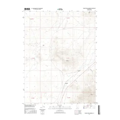
2017 Map of Tanner Creek Narrows
USGS Topo · Published 2017About this map
Champlin sits at a critical junction of valley and mountain in this part of Juab County, where the desert floor meets the rising elevations of the Black Mountains and Gilson Mountains. The landscape is defined by drainage patterns and seasonal waterways, most notably the Jericho Wash and the winding course of Tanner Cr. This 2017 survey reveals a network of industrial and backcountry routes, including Coal Rd and Cardson Gravel Pit Rds 1, indicating the area's continued role in resource extraction and transit. The topographic relief is most pronounced at Jericho Ridge and the Tanner Creek Narrows, where the terrain constricts. Sand Mt Rd provides access to the higher elevations in the northern sections, illustrating the sparse but deliberate infrastructure required to navigate this portion of the eastern Great Basin.
Find a feature on this map
17 named features on this map. Tap any name to fly to it.
Don’t see what you’re looking for? This feature index may not catch every label — zoom into the map to look around manually.
Map Details
Editions of this 2017 Tanner Creek Narrows Map
This is the sole edition of this map. No revisions or reprints were ever made.
Other maps of this area

1885 · Sevier Desert
USGS Topo · 1:250,000

1953 · Delta
USGS Topo · 1:250,000
1954 · Mc Intyre
USGS Topo · 1:24,000

1958 · Delta
USGS Topo · 1:250,000

1962 · Delta
USGS Topo · 1:250,000
1962 · Lynndyl
USGS Topo · 1:62,500
1963 · Maple Peak
USGS Topo · 1:24,000
1963 · Cherry Creek
USGS Topo · 1:24,000
1967 · Champlin Peak
USGS Topo · 1:24,000
1967 · Jericho
USGS Topo · 1:24,000