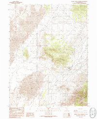
1986 Map of Tanner Creek Narrows
USGS Topo · Published 1986About this map
The Little Sahara National Recreation Area dominates the western landscape of this Juab County region, showcasing a distinctive expanse of sand dunes and open terrain. In the mid-1980s, this area served as a transition between the shifting sands of the recreation area and the more stable elevations of the Black Mountains and the Gilson Mountains to the southeast. The small settlement of Jericho sits in the northern flats, while Champlin is positioned further south near the drainage of Tanner Creek. The topography is defined by significant watercourse features like the Tanner Creek Narrows and the Black Rock Wash, which cut through the high ground. Small-scale industrial activity is evidenced by a Gravel Pit located near the mountains, providing a look at the local land use and infrastructure during this period of the late twentieth century.
Find a feature on this map
10 named features on this map. Tap any name to fly to it.
Don’t see what you’re looking for? This feature index may not catch every label — zoom into the map to look around manually.
Map Details
Editions of this 1986 Tanner Creek Narrows Map
This is the sole edition of this map. No revisions or reprints were ever made.
Other maps of this area

1885 · Sevier Desert
USGS Topo · 1:250,000

1953 · Delta
USGS Topo · 1:250,000

1954 · Mc Intyre
USGS Topo · 1:24,000

1958 · Delta
USGS Topo · 1:250,000

1962 · Delta
USGS Topo · 1:250,000

1962 · Lynndyl
USGS Topo · 1:62,500

1963 · Maple Peak
USGS Topo · 1:24,000

1963 · Cherry Creek
USGS Topo · 1:24,000

1967 · Champlin Peak
USGS Topo · 1:24,000
1967 · Jericho
USGS Topo · 1:24,000