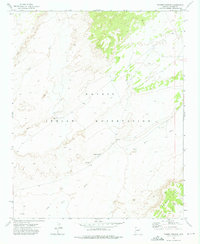
1972 Map of Tanner Springs
USGS Topo · Published 1975About this map
Navajo Indian Reservation lands dominate this high-desert landscape in northeastern Arizona, where the confluence of several seasonal drainages defines the local geography. The settlement at Tanner Springs is positioned near the junction of Sabito Wash and Wide Ruin Wash, indicating the importance of these watercourses for habitation and travel in an arid region. The presence of Hogan, a traditional Navajo dwelling label, alongside several water sources like Clark Well, Spring, and Springs, underscores the character of pastoral life and indigenous land use during this era. In the southeastern corner, the rising elevation of Padres Mesa provides a distinct topographical boundary, while the scattered infrastructure of Water Tank sites and wells reflects the sparse but essential network required for livestock and survival on the reservation.
Find a feature on this map
11 named features on this map. Tap any name to fly to it.
Don’t see what you’re looking for? This feature index may not catch every label — zoom into the map to look around manually.
Map Details
Editions of this 1972 Tanner Springs Map
This is the sole edition of this map. No revisions or reprints were ever made.
Other maps of this area

1886 · Fort Defiance
USGS Topo · 1:250,000

1892 · Fort Defiance
USGS Topo · 1:250,000

1954 · Gallup
USGS Topo · 1:250,000

1958 · Gallup
USGS Topo · 1:250,000

1959 · Gallup
USGS Topo · 1:250,000

1962 · Gallup
USGS Topo · 1:250,000

1967 · Gallup
USGS Topo · 1:250,000
1972 · Navajo North
USGS Topo · 1:24,000
1972 · North Mill Well
USGS Topo · 1:24,000
1972 · Chinde Mesa
USGS Topo · 1:24,000