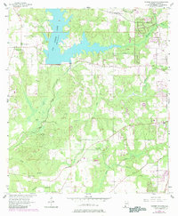
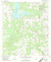
1957 Map of Tanner Williams
USGS Topo · Published 1984About this map
Big Creek Lake dominates the northern landscape of this Mobile County survey, its irregular shoreline formed by the flooding of Big Creek and its tributaries like Crooked Creek. The settlement of Tanner Williams sits to the west of the reservoir, serving as a focal point for local genealogy with the nearby Williams Cem and Tanner Cem. This era shows a transition in land use, where traditional rural life—marked by numerous country churches such as Allentown Ch and Pierce Ch—exists alongside mid-century infrastructure like the Radio Range Station and Bates Field.
Find a feature on this map
35 named features on this map. Tap any name to fly to it.
Don’t see what you’re looking for? This feature index may not catch every label — zoom into the map to look around manually.
Map Details
Editions of this 1957 Tanner Williams Map
5 editions found
Other maps of this area

1922 · Mobile
USGS Topo · 1:62,500

1940 · Mobile
USGS Topo · 1:62,500

1941 · Hurley
USGS Topo · 1:62,500

1941 · Creola
USGS Topo · 1:62,500

1942 · Kushla
USGS Topo · 1:31,680

1942 · Theodore
USGS Topo · 1:31,680

1942 · Wilmer
USGS Topo · 1:62,500

1943 · Theodore
USGS Topo · 1:31,680

1943 · Creola
USGS Topo · 1:62,500

1943 · Hurley
USGS Topo · 1:62,500