
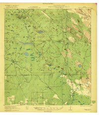
1921 Map of Tarida Ranch
USGS Topo · Published 1921About this map
Vast ranching estates define this South Texas landscape during the early 1920s, a period when life in this brush country revolved around dispersed family-named holdings and critical water sources. The Tarida Ranch and surrounding properties like San Luis Ranch and Campo Verde Ranch are connected by a network of unimproved roads and cattle trails. This environment demanded reliable water access, as evidenced by named features such as Rosita Lake and infrastructure like Tate Well and Sarita Well.
Find a feature on this map
16 named features on this map. Tap any name to fly to it.
Don’t see what you’re looking for? This feature index may not catch every label — zoom into the map to look around manually.
Map Details
Editions of this 1921 Tarida Ranch Map
2 editions found
Other maps of this area

1922 · La Sal Vieja
USGS Topo · 1:62,500

1923 · Armstrong
USGS Topo · 1:62,500

1923 · Lopena Island
USGS Topo · 1:62,500

1923 · Saltillo Ranch
USGS Topo · 1:62,500

1952 · South of Potrero Lopeno NW
USGS Topo · 1:24,000

1952 · Hawk Island
USGS Topo · 1:24,000

1952 · Port Mansfield
USGS Topo · 1:24,000

1952 · Potrero Lopeno SW
USGS Topo · 1:24,000

1952 · Potrero Lopeno
USGS Topo · 1:62,500

1952 · South of Potrero Lopeno
USGS Topo · 1:62,500