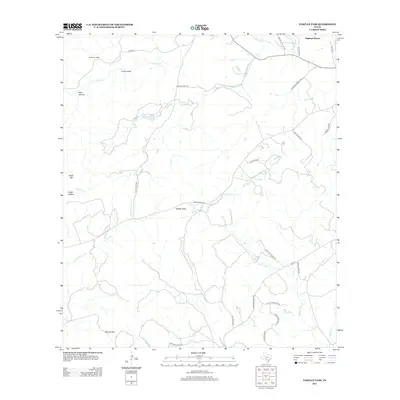
2013 Map of Tarpley Pass
USGS Topo · Published 2013About this map
Tarpley Pass anchors this 2013 study of the Texas Hill Country, a landscape defined by sharp divides and named water sources. The map details a network of canyons and gaps, including Elam Canyon and Barnes Gap, alongside significant elevations such as Chalk Mtn. Settlement patterns are concentrated around large ranching properties and small developments, notably El Paraiso Ranch and the newer cluster at Highland Waters near the Medina River.
Find a feature on this map
36 named features on this map. Tap any name to fly to it.
Don’t see what you’re looking for? This feature index may not catch every label — zoom into the map to look around manually.
Map Details
Editions of this 2013 Tarpley Pass Map
This is the sole edition of this map. No revisions or reprints were ever made.
Other maps of this area
1954 · San Antonio
USGS Topo · 1:250,000
1956 · Tarpley
USGS Topo · 1:62,500
1956 · Tuff
USGS Topo · 1:62,500
1956 · Bandera
USGS Topo · 1:62,500
1956 · Center Point
USGS Topo · 1:62,500
1957 · San Antonio
USGS Topo · 1:250,000
1964 · Bandera
USGS Topo · 1:24,000
1964 · Timber Creek
USGS Topo · 1:24,000
1964 · Rock Cliff Reservoir
USGS Topo · 1:24,000
1964 · A Bar A Ranch
USGS Topo · 1:24,000