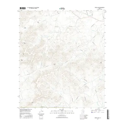
2016 Map of Tarpley Pass
USGS Topo · Published 2016About this map
Tarpley Pass serves as a central landmark in this 2016 survey of the Texas Hill Country, where the landscape is defined by a dense network of seasonal creeks and named topographical features. The drainage patterns of Middle Verde Cr, W Verde Cr, and Winans Cr illustrate the complex hydrology that has shaped local ranching traditions. Evidence of long-standing land use appears in the numerous named gaps and hollows, such as Barnes Gap and Cedar Hollow, which historically dictated travel and settlement patterns across the Bandera Co line.
Find a feature on this map
39 named features on this map. Tap any name to fly to it.
Don’t see what you’re looking for? This feature index may not catch every label — zoom into the map to look around manually.
Map Details
Editions of this 2016 Tarpley Pass Map
This is the sole edition of this map. No revisions or reprints were ever made.
Other maps of this area
1954 · San Antonio
USGS Topo · 1:250,000
1956 · Tarpley
USGS Topo · 1:62,500
1956 · Tuff
USGS Topo · 1:62,500
1956 · Bandera
USGS Topo · 1:62,500
1956 · Center Point
USGS Topo · 1:62,500
1957 · San Antonio
USGS Topo · 1:250,000
1964 · Bandera
USGS Topo · 1:24,000
1964 · Timber Creek
USGS Topo · 1:24,000
1964 · Rock Cliff Reservoir
USGS Topo · 1:24,000
1964 · A Bar A Ranch
USGS Topo · 1:24,000