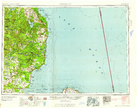
1958 Map of Tawas City
USGS Topo · Published 1958About this map
The Huron National Forest dominates this mid-century landscape, framing the industrial and maritime activity along the Western Shore. Along the coast, the Detroit and Mackinac RR serves as a vital artery, connecting timber and mining towns like Oscoda, Tawas City, and Alabaster where a bucket cable line extends into the bay. The map documents a significant military presence at the Wurtsmith Bombing and Gunnery Range, reflecting the era's Cold War strategic importance.
Find a feature on this map
77 named features on this map. Tap any name to fly to it.
Don’t see what you’re looking for? This feature index may not catch every label — zoom into the map to look around manually.
Map Details
Editions of this 1958 Tawas City Map
2 editions found

Other maps of this area

1954 · Traverse City
USGS Topo · 1:250,000

1954 · Midland
USGS Topo · 1:250,000

1954 · Flint
USGS Topo · 1:250,000

1954 · Tawas City
USGS Topo · 1:250,000

1954 · Alpena
USGS Topo · 1:250,000

1955 · Atlanta
USGS Topo · 1:62,500

1955 · Comins
USGS Topo · 1:62,500

1955 · Hillman
USGS Topo · 1:62,500

1955 · Cheboygan
USGS Topo · 1:250,000

1957 · Alpena
USGS Topo · 1:250,000