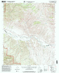
1995 Map of Taylor Canyon
USGS Topo · Published 2000About this map
The Cuyama Grant (Maria Antonia De La Guerra Y Lataillade) and the Cuyama Grant (Heirs Of Cesario Lataillade) dominate the central valley of this mid-1990s survey, reflecting the enduring legacy of Spanish and Mexican land grants along the Cuyama River. This arid corridor between the Caliente Range and the Sierra Madre Mts is marked by isolated agricultural and ranching operations like Spanish Ranch, Green Valley Ranch No 2, and Rickard.
Find a feature on this map
31 named features on this map. Tap any name to fly to it.
Don’t see what you’re looking for? This feature index may not catch every label — zoom into the map to look around manually.
Map Details
Editions of this 1995 Taylor Canyon Map
This is the sole edition of this map. No revisions or reprints were ever made.
Other maps of this area

1902 · Santa Ynez
USGS Topo · 1:125,000

1905 · Santa Ynez
USGS Topo · 1:125,000

1905 · Lompoc
USGS Topo · 1:125,000

1912 · McKittrick
USGS Topo · 1:125,000

1937 · Branch Mtn
USGS Topo · 1:48,000

1941 · Caliente Mountain
USGS Topo · 1:62,500

1941 · McPherson Peak
USGS Topo · 1:62,500

1942 · Lompoc
USGS Topo · 1:125,000

1942 · Branch Mountain
USGS Topo · 1:62,500

1942 · Caliente Mtn
USGS Topo · 1:62,500