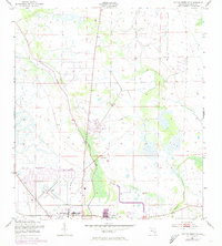
1953 Map of Taylor Creek SE
USGS Topo · Published 1973About this map
Okeechobee serves as the hub of this South Florida landscape, where the town's expansion is reflected in mid-century residential developments like Basswood Estates and Whispering Pines. The map captures a transition in local infrastructure, showing the Seaboard Coast Line running alongside an Old Railroad Grade, tracing the path of former rail operations through the marshy terrain. Educational and social landmarks are prominent, including the Florida School for Boys and Brown High Sch, while local neighborhoods such as Barber Quarters and Cypress Quarters indicate the segregated residential patterns typical of the era. To the north, the meandering path of Taylor Creek defines the drainage of the area, complemented by Mosquito Creek to the southeast, illustrating the hydrological management essential to this low-lying region near the great lake.
Find a feature on this map
13 named features on this map. Tap any name to fly to it.
Don’t see what you’re looking for? This feature index may not catch every label — zoom into the map to look around manually.
Map Details
Editions of this 1953 Taylor Creek SE Map
3 editions found
Other maps of this area

1952 · Okeechobee NW
USGS Topo · 1:24,000

1952 · Okeechobee
USGS Topo · 1:24,000

1953 · Taylor Creek NW
USGS Topo · 1:24,000

1953 · Okeechobee 4 NW
USGS Topo · 1:24,000

1953 · Taylor Creek SW
USGS Topo · 1:24,000

1953 · Okeechobee 1 SW
USGS Topo · 1:24,000

1953 · Taylor Creek SE
USGS Topo · 1:24,000

1953 · Taylor Creek NE
USGS Topo · 1:24,000

1953 · Okeechobee 1 NW
USGS Topo · 1:24,000

1956 · Fort Pierce
USGS Topo · 1:250,000
Featured Places
- Okeechobee, FL
- Basswood Estates, FL
- Cypress Quarters, FL
- Barber Quarters, Okeechobee
- Whispering Pines, FL