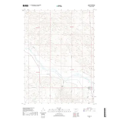
2017 Map of Taylor
USGS Topo · Published 2017About this map
Taylor serves as the focal point of this Loup County landscape, situated on the southern banks of the North Loup River. The town's grid is clearly defined by streets like Broadway St and Fay St, while the Taylor Cem lies just to the south. The surrounding terrain reveals a complex network of water management and natural drainage, characterized by the Taylor-Ord Canal running parallel to the river and Spring Cr winding through the western sections. The rural character of the region is further evidenced by a system of section-line roads and named paths such as Sunnyside Rd and Madison Square Rd, which navigate the elevation changes near Chesbra Canyon. This geography highlights the essential relationship between the central settlement and the vital water resources of the river valley.
Find a feature on this map
23 named features on this map. Tap any name to fly to it.
Don’t see what you’re looking for? This feature index may not catch every label — zoom into the map to look around manually.
Map Details
Editions of this 2017 Taylor Map
This is the sole edition of this map. No revisions or reprints were ever made.
Other maps of this area
1951 · Walworth
USGS Topo · 1:24,000
1952 · Sargent East
USGS Topo · 1:24,000
1952 · Taylor NW
USGS Topo · 1:24,000
1952 · Almeria NE
USGS Topo · 1:24,000
1952 · Sargent West
USGS Topo · 1:24,000
1952 · Taylor SE
USGS Topo · 1:24,000
1952 · Almeria
USGS Topo · 1:24,000
1952 · Taylor
USGS Topo · 1:24,000
1952 · Taylor NE
USGS Topo · 1:24,000
1955 · Broken Bow
USGS Topo · 1:250,000