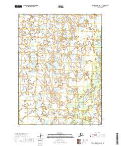
2019 Map of Taylor Mountains A-2 SE
USGS Topo · Published 2019About this map
The Mulchatna River winds through this interior Alaskan landscape, shaping a complex network of wetlands and seasonal watercourses in the Dillingham Census Area. This 2019 survey captures the river's meandering path and its relationship with tributaries like Dixie Creek and Old Man Cr. The terrain is characterized by a dense pattern of small ponds and unnamed lakes, illustrating the shifting hydrology of the region as these waterways migrate across the low-lying plains. The absence of roads or established settlements emphasizes the remote, undisturbed character of the river system, which remains a critical corridor for subsistence and travel in the Alaskan bush. Genealogists and researchers can use the detailed public land survey system grids, including t1s r42w and t2s r41w, to pinpoint specific geographical coordinates in this expansive river basin.
Find a feature on this map
8 named features on this map. Tap any name to fly to it.
Don’t see what you’re looking for? This feature index may not catch every label — zoom into the map to look around manually.
Map Details
Editions of this 2019 Taylor Mountains A-2 SE Map
This is the sole edition of this map. No revisions or reprints were ever made.
Other maps of this area

1950 · Taylor Mountains
USGS Topo · 1:250,000

1951 · Taylor Mountains
USGS Topo · 1:250,000

1951 · Dillingham
USGS Topo · 1:250,000

1954 · Taylor Mountains
USGS Topo · 1:250,000

1954 · Dillingham
USGS Topo · 1:250,000

1954 · Dillingham D-2
USGS Topo · 1:63,360

1954 · Taylor Mountains A-2
USGS Topo · 1:63,360

1954 · Dillingham D-1
USGS Topo · 1:63,360
1954 · Taylor Mountains A-1
USGS Topo · 1:63,360
2019 · Dillingham D-2 NE
USGS Topo · 1:25,000