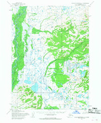
1954 Map of Taylor Mountains A-1
USGS Topo · Published 1968About this map
The Mulchatna River dominates this southwestern Alaskan landscape, flowing through a vast network of wetlands and tundra before the modern era of development. The terrain is defined by its complex drainage systems, where the Swan River and Koktuli River meet a dense collection of unnamed lakes and ponds. Higher ground is found at Beaver Mtn and the Jack Rabbit Hills, providing contrast to the low-lying river valleys. Human presence is sparse, marked only by an isolated Cabin and the Ruins Cabin along the riverbanks, suggesting seasonal use or early trapping outposts. These land lines, predetermined by the Bureau of Land Management, represent unsurveyed territory at the time of the 1954 field annotation, capturing the area in a raw state of wilderness.
Find a feature on this map
11 named features on this map. Tap any name to fly to it.
Don’t see what you’re looking for? This feature index may not catch every label — zoom into the map to look around manually.
Map Details
Editions of this 1954 Taylor Mountains A-1 Map
2 editions found
Other maps of this area

1946 · Lake Clark
USGS Topo · 1:250,000

1950 · Taylor Mountains
USGS Topo · 1:250,000

1951 · Lake Clark
USGS Topo · 1:250,000

1951 · Taylor Mountains
USGS Topo · 1:250,000

1951 · Dillingham
USGS Topo · 1:250,000

1952 · Iliamna
USGS Topo · 1:250,000

1954 · Lake Clark A-8
USGS Topo · 1:63,360

1954 · Iliamna D-8
USGS Topo · 1:63,360

1954 · Taylor Mountains
USGS Topo · 1:250,000

1954 · Dillingham
USGS Topo · 1:250,000