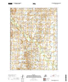
2019 Map of Taylor Mountains A-2 SW
USGS Topo · Published 2019About this map
Old Man Cr winds through this interior landscape in the Dillingham area of Alaska, defining the central hydrography of a vast wetland complex. The terrain is characterized by a dense network of ponds and saturated ground typical of the t1s r43w and t2s r43w townships. This 2019 survey, produced by the U.S. Geological Survey, illustrates a landscape almost entirely defined by its water systems and natural drainages rather than human infrastructure or settlements. The survey provides a clear view of the complex hydrology of the region, where the creek meanders across township lines including t1s r42w and t2s r42w. For those studying the remote geography of Southwest Alaska, the map offers a detailed record of the shifting water bodies and topographic contours in an area without established roads or permanent buildings.
Find a feature on this map
5 named features on this map. Tap any name to fly to it.
Don’t see what you’re looking for? This feature index may not catch every label — zoom into the map to look around manually.
Map Details
Editions of this 2019 Taylor Mountains A-2 SW Map
This is the sole edition of this map. No revisions or reprints were ever made.
Other maps of this area

1950 · Taylor Mountains
USGS Topo · 1:250,000

1951 · Taylor Mountains
USGS Topo · 1:250,000

1951 · Dillingham
USGS Topo · 1:250,000

1954 · Taylor Mountains
USGS Topo · 1:250,000

1954 · Dillingham
USGS Topo · 1:250,000

1954 · Dillingham D-2
USGS Topo · 1:63,360

1954 · Dillingham D-3
USGS Topo · 1:63,360

1954 · Taylor Mountains A-2
USGS Topo · 1:63,360
1954 · Taylor Mountains A-3
USGS Topo · 1:63,360
2019 · Dillingham D-2 NE
USGS Topo · 1:25,000