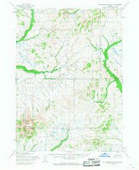
1954 Map of Taylor Mountains A-3
USGS Topo · Published 1968About this map
Sleitat Mountain rises as the primary topographic landmark in this interior Alaskan wilderness, captured through photogrammetric methods from aerial surveys conducted in the early 1950s. The landscape is defined by its drainage systems, most notably the winding paths of Yukpatik Creek in the north and the westward flow of Old Man Creek. The Base Line survey marker bisects the quadrangle, indicating the early stages of formal land partitioning by the Bureau of Land Management. While devoid of permanent settlements or roads at the time of the survey, the presence of Harris Creek and numerous unnamed tributaries suggests a complex hydrological network typical of the Dillingham region. This document represents a fundamental stage in mapping the Alaskan interior, where terrain and water governed movement and potential exploration before any modern infrastructure was established.
Find a feature on this map
5 named features on this map. Tap any name to fly to it.
Don’t see what you’re looking for? This feature index may not catch every label — zoom into the map to look around manually.
Map Details
Editions of this 1954 Taylor Mountains A-3 Map
2 editions found
Other maps of this area

1950 · Taylor Mountains
USGS Topo · 1:250,000

1951 · Taylor Mountains
USGS Topo · 1:250,000

1951 · Dillingham
USGS Topo · 1:250,000

1954 · Taylor Mountains
USGS Topo · 1:250,000

1954 · Dillingham
USGS Topo · 1:250,000
1954 · Taylor Mountains B-2
USGS Topo · 1:63,360

1954 · Dillingham D-2
USGS Topo · 1:63,360

1954 · Dillingham D-3
USGS Topo · 1:63,360

1954 · Taylor Mountains A-4
USGS Topo · 1:63,360

1954 · Dillingham D-4
USGS Topo · 1:63,360