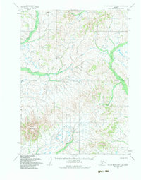
1954 Map of Taylor Mountains A-3
USGS Topo · Published 1983About this map
Sleitat Mountain anchors this mid-century topographic survey of the Taylor Mountains region in southwestern Alaska. The terrain is defined by a dense network of subarctic waterways, where the southern flow of Harris Creek and the meandering path of Old Man Creek dominate the drainage patterns. To the northwest, Vukpalik Creek carves through the land, illustrating the transition from highland ridges to lower swampy basins. This 1954 data, compiled by the Defense Mapping Agency and the Geological Survey from aerial photography, captures a landscape devoid of permanent settlements or roads. The map highlights the intersection of the regional Base Line, providing a foundational view of the remote wilderness before modern development or environmental shifts altered the hydrology of these interior valleys.
Find a feature on this map
5 named features on this map. Tap any name to fly to it.
Don’t see what you’re looking for? This feature index may not catch every label — zoom into the map to look around manually.
Map Details
Editions of this 1954 Taylor Mountains A-3 Map
2 editions found
Other maps of this area

1950 · Taylor Mountains
USGS Topo · 1:250,000

1951 · Taylor Mountains
USGS Topo · 1:250,000

1951 · Dillingham
USGS Topo · 1:250,000

1954 · Taylor Mountains
USGS Topo · 1:250,000

1954 · Dillingham
USGS Topo · 1:250,000
1954 · Taylor Mountains B-2
USGS Topo · 1:63,360

1954 · Dillingham D-2
USGS Topo · 1:63,360

1954 · Dillingham D-3
USGS Topo · 1:63,360

1954 · Taylor Mountains A-4
USGS Topo · 1:63,360

1954 · Dillingham D-4
USGS Topo · 1:63,360