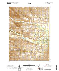
2019 Map of Taylor Mountains B-6 SE
USGS Topo · Published 2019About this map
The King Salmon River meanders through this landscape in the Dillingham area, defined by the expansive drainage basins and rising elevation of southwest Alaska. This 2019 survey documents the complex topography across several townships, including t3n r51w, t3n r50w, t2n r51w, and t2n r50w. The relief shown illustrates the intricate valley systems and high ridges that characterize this part of the Taylor Mountains quadrangle. For researchers tracking the hydrography of the region, the map provides a clear look at the braided nature of the main river course as it flows south through the central and eastern sections of the territory.
Find a feature on this map
5 named features on this map. Tap any name to fly to it.
Don’t see what you’re looking for? This feature index may not catch every label — zoom into the map to look around manually.
Map Details
Editions of this 2019 Taylor Mountains B-6 SE Map
This is the sole edition of this map. No revisions or reprints were ever made.
Other maps of this area

1950 · Taylor Mountains
USGS Topo · 1:250,000

1951 · Taylor Mountains
USGS Topo · 1:250,000

1954 · Taylor Mountains
USGS Topo · 1:250,000

1954 · Taylor Mountains B-5
USGS Topo · 1:63,360

1954 · Taylor Mountains B-6
USGS Topo · 1:63,360

1954 · Taylor Mountains A-5
USGS Topo · 1:63,360

1954 · Taylor Mountains A-6
USGS Topo · 1:63,360
2019 · Taylor Mountains A-5 NW
USGS Topo · 1:25,000
2019 · Taylor Mountains B-5 SW
USGS Topo · 1:25,000
2019 · Taylor Mountains A-6 NE
USGS Topo · 1:25,000