
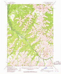
1954 Map of Taylor Mountains B-5
USGS Topo · Published 1968About this map
King Salmon River defines the southern reaches of this interior Alaskan wilderness, as seen through topographic surveys conducted in the mid-1950s. The landscape is characterized by a complex network of unnamed ridges and drainage basins, where the absence of roads or trails highlights the isolation of this region within the Taylor Mountains B-5 quadrangle. The map reflects a period of extensive photogrammetric mapping by the Army Map Service, relying on aerial photographs from 1953 and 1955 to chart terrain that had not yet been field-checked. This document records the intricate contour intervals and watercourse patterns of the Seward Meridian before any significant human infrastructure or named settlements reached this part of the territory.
Find a feature on this map
1 named feature on this map. Tap any name to fly to it.
Don’t see what you’re looking for? This feature index may not catch every label — zoom into the map to look around manually.
Map Details
Editions of this 1954 Taylor Mountains B-5 Map
This is the sole edition of this map. No revisions or reprints were ever made.
Other maps of this area

1950 · Taylor Mountains
USGS Topo · 1:250,000

1951 · Taylor Mountains
USGS Topo · 1:250,000

1954 · Taylor Mountains
USGS Topo · 1:250,000

1954 · Taylor Mountains C-4
USGS Topo · 1:63,360

1954 · Taylor Mountains A-4
USGS Topo · 1:63,360
1954 · Taylor Mountains C-5
USGS Topo · 1:63,360

1954 · Taylor Mountains B-6
USGS Topo · 1:63,360

1954 · Taylor Mountains A-5
USGS Topo · 1:63,360

1954 · Taylor Mountains C-6
USGS Topo · 1:63,360

1954 · Taylor Mountains A-6
USGS Topo · 1:63,360