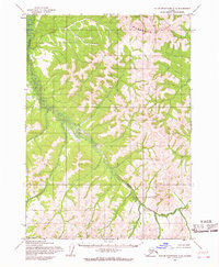
1954 Map of Taylor Mountains C-5
USGS Topo · Published 1968About this map
Nushagak Hills define the northern terrain of this interior Alaskan landscape, which was mapped by the Army Map Service in the mid-1950s. The region is characterized by a winding drainage system, most notably the meandering course of Shotgun Creek as it cuts through the upland topography. Based on photogrammetric methods from aerial photographs taken in 1953 and 1955, the survey illustrates a wilderness prior to significant modern development or established infrastructure. The land lines shown represent unsurveyed and unmarked locations predetermined by the Bureau of Land Management, reflecting the administrative organization of the Seward Meridian during this era of territorial oversight.
Find a feature on this map
2 named features on this map. Tap any name to fly to it.
Don’t see what you’re looking for? This feature index may not catch every label — zoom into the map to look around manually.
Map Details
Editions of this 1954 Taylor Mountains C-5 Map
2 editions found
Other maps of this area

1950 · Taylor Mountains
USGS Topo · 1:250,000

1951 · Taylor Mountains
USGS Topo · 1:250,000

1954 · Taylor Mountains
USGS Topo · 1:250,000

1954 · Taylor Mountains D-6
USGS Topo · 1:63,360

1954 · Taylor Mountains D-5
USGS Topo · 1:63,360

1954 · Taylor Mountains C-4
USGS Topo · 1:63,360

1954 · Taylor Mountains B-5
USGS Topo · 1:63,360

1954 · Taylor Mountains D-4
USGS Topo · 1:63,360

1954 · Taylor Mountains B-6
USGS Topo · 1:63,360

1954 · Taylor Mountains C-6
USGS Topo · 1:63,360