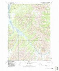
1954 Map of Taylor Mountains C-5
USGS Topo · Published 1987About this map
Nushagak Hills define the terrain of this interior Alaskan landscape as it was documented in the mid-1950s. The topographic survey focuses on the winding path of Shotgun Creek, which carves through a complex network of high ridges and narrow valleys. This area is notably characterized by its lack of infrastructure, with the map notes explicitly stating that no roads or trails existed in this portion of the Taylor Mountains at the time of the survey. The drainage patterns and 25-foot contour intervals reveal a wilderness defined by water and elevation, offering a precise look at the geography before modern changes. It serves as a foundational record of the regional hydrology and landform elevations as captured by photogrammetric methods.
Find a feature on this map
2 named features on this map. Tap any name to fly to it.
Don’t see what you’re looking for? This feature index may not catch every label — zoom into the map to look around manually.
Map Details
Editions of this 1954 Taylor Mountains C-5 Map
2 editions found
Other maps of this area

1950 · Taylor Mountains
USGS Topo · 1:250,000

1951 · Taylor Mountains
USGS Topo · 1:250,000

1954 · Taylor Mountains
USGS Topo · 1:250,000

1954 · Taylor Mountains D-6
USGS Topo · 1:63,360

1954 · Taylor Mountains D-5
USGS Topo · 1:63,360

1954 · Taylor Mountains C-4
USGS Topo · 1:63,360

1954 · Taylor Mountains B-5
USGS Topo · 1:63,360

1954 · Taylor Mountains D-4
USGS Topo · 1:63,360
1954 · Taylor Mountains C-5
USGS Topo · 1:63,360

1954 · Taylor Mountains B-6
USGS Topo · 1:63,360