
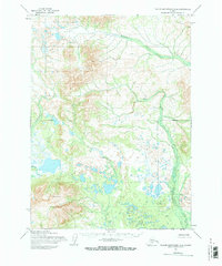
1954 Map of Taylor Mountains A-6
USGS Topo · Published 1968About this map
Tikchik Mountain anchors the southern portion of this landscape, which was primarily mapped via photogrammetric methods from aerial photographs taken in the mid-1950s. The region is defined by an intricate network of water bodies and marshlands, with drainage systems such as Klutuspah Creek and Arrow Creek meandering through the interior. A prominent Ridge extends across the northern section, while Koneruk Creek flows toward the west. The 1954 field annotation captured a territory that remained largely unsurveyed on the ground, as evidenced by the Base Line and other land lines representing locations predetermined by the Bureau of Land Management rather than marked in the field. This survey represents a remote Alaskan wilderness at a time when mapping technologies were transitioning toward aerial reliance, documenting a land of unnamed lakes and high ridges before more modern infrastructure arrived.
Find a feature on this map
6 named features on this map. Tap any name to fly to it.
Don’t see what you’re looking for? This feature index may not catch every label — zoom into the map to look around manually.
Map Details
Editions of this 1954 Taylor Mountains A-6 Map
2 editions found
Other maps of this area

1950 · Taylor Mountains
USGS Topo · 1:250,000

1951 · Taylor Mountains
USGS Topo · 1:250,000

1951 · Dillingham
USGS Topo · 1:250,000

1954 · Taylor Mountains
USGS Topo · 1:250,000

1954 · Dillingham
USGS Topo · 1:250,000

1954 · Dillingham D-6
USGS Topo · 1:63,360

1954 · Dillingham D-7
USGS Topo · 1:63,360
1954 · Dillingham D-5
USGS Topo · 1:63,360

1954 · Taylor Mountains B-7
USGS Topo · 1:63,360

1954 · Taylor Mountains B-5
USGS Topo · 1:63,360