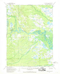
1954 Map of Dillingham D-5
USGS Topo · Published 1968About this map
The Nuyakuk River dominates this mid-1950s interior landscape, winding in complex oxbows and secondary channels through an area characterized by intricate wetlands and numerous unnamed ponds. This survey reflects the remote character of the region during the mid-twentieth century, with surveying based on aerial photography taken in 1955. In the southern portion of the quadrangle, Napotoli Creek flows through the lowlands, representing the few named waterways in a vast expanse of unsurveyed and unmarked land lines. The lack of roads, trails, or settlements on this map underscores the isolation of the Alaskan interior prior to significant modern development, preserving a record of the natural hydrology and drainage patterns of the Seward Meridian before the landscape was further altered by human infrastructure.
Find a feature on this map
2 named features on this map. Tap any name to fly to it.
Don’t see what you’re looking for? This feature index may not catch every label — zoom into the map to look around manually.
Map Details
Editions of this 1954 Dillingham D-5 Map
2 editions found
Other maps of this area

1950 · Taylor Mountains
USGS Topo · 1:250,000

1951 · Taylor Mountains
USGS Topo · 1:250,000

1951 · Dillingham
USGS Topo · 1:250,000

1954 · Taylor Mountains
USGS Topo · 1:250,000

1954 · Dillingham
USGS Topo · 1:250,000

1954 · Dillingham C-6
USGS Topo · 1:63,360

1954 · Dillingham D-6
USGS Topo · 1:63,360

1954 · Taylor Mountains A-4
USGS Topo · 1:63,360

1954 · Dillingham D-4
USGS Topo · 1:63,360

1954 · Taylor Mountains A-5
USGS Topo · 1:63,360