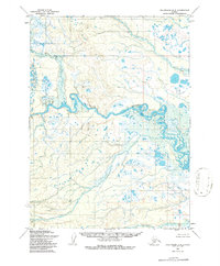
1954 Map of Dillingham D-5
USGS Topo · Published 1986About this map
The Nuyakuk River dominates this mid-century topographic survey, winding through an intricate network of marshes and unnamed glacial lakes in the Bristol Bay region. Based on 1950s aerial photography with 1985 revisions, the map reveals a landscape defined by water and permafrost, where the lack of roads or trails highlights the region's reliance on river navigation. In the southern portion of the quadrangle, Napotoli Creek drains toward the larger river systems through a maze of ponds and wetlands. This document serves as a precise record of the hydrological patterns and topographic elevations before modern shifts in the subarctic environment, preserving the exact contours of the many unnamed islands and oxbow lakes created by the meandering river channels.
Find a feature on this map
2 named features on this map. Tap any name to fly to it.
Don’t see what you’re looking for? This feature index may not catch every label — zoom into the map to look around manually.
Map Details
Editions of this 1954 Dillingham D-5 Map
2 editions found
Other maps of this area

1950 · Taylor Mountains
USGS Topo · 1:250,000

1951 · Taylor Mountains
USGS Topo · 1:250,000

1951 · Dillingham
USGS Topo · 1:250,000

1954 · Taylor Mountains
USGS Topo · 1:250,000

1954 · Dillingham
USGS Topo · 1:250,000

1954 · Dillingham C-6
USGS Topo · 1:63,360

1954 · Dillingham D-6
USGS Topo · 1:63,360
1954 · Dillingham D-5
USGS Topo · 1:63,360

1954 · Taylor Mountains A-4
USGS Topo · 1:63,360

1954 · Dillingham D-4
USGS Topo · 1:63,360