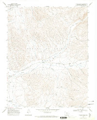
1967 Map of Taylor Ranch
USGS Topo · Published 1971About this map
The Sangre De Cristo Grant dominates this 1967 survey of Costilla County, showing the traditional settlement patterns of the Culebra River valley. Small villages such as Chama and Los Fuertes are positioned along the lower elevations, where the Sanchez Canal and Culebra Creek provide vital irrigation for the surrounding agricultural lands. The map details the local religious and civic landscape, including the Cañon Ch and the Chama Cem, which serve these tight-knit communities.
Find a feature on this map
22 named features on this map. Tap any name to fly to it.
Don’t see what you’re looking for? This feature index may not catch every label — zoom into the map to look around manually.
Map Details
Editions of this 1967 Taylor Ranch Map
3 editions found
Other maps of this area

1954 · Trinidad
USGS Topo · 1:250,000

1955 · Trinidad
USGS Topo · 1:250,000

1958 · Trinidad
USGS Topo · 1:250,000

1959 · Trinidad
USGS Topo · 1:250,000

1967 · San Luis
USGS Topo · 1:24,000

1967 · La Valley
USGS Topo · 1:24,000

1967 · Fort Garland SW
USGS Topo · 1:24,000

1967 · Ojito Peak
USGS Topo · 1:24,000

1967 · Taylor Ranch
USGS Topo · 1:24,000
1967 · Culebra Peak
USGS Topo · 1:24,000