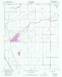
1950 Map of Taylor Weir
USGS Topo · Published 1985About this map
The hydrological management of the San Joaquin Valley is clearly visible in this mid-century landscape, dominated by the winding course of the Tule River and its intricate drainage network. Water control is a central theme, evidenced by the eponymous Taylor Weir and the nearby Lakeland Canal. The map reveals a transition in the river's path, showing the Old Channel Tule River alongside modern diversions. Agriculture and transit define the land use, with the Atchison Topeka and Santa Fe railroad cutting through the southwestern corner.
Find a feature on this map
14 named features on this map. Tap any name to fly to it.
Don’t see what you’re looking for? This feature index may not catch every label — zoom into the map to look around manually.
Map Details
Editions of this 1950 Taylor Weir Map
3 editions found
Other maps of this area

1914 · Lost Hills
USGS Topo · 1:125,000

1925 · Tulare
USGS Topo · 1:31,680

1925 · Tipton
USGS Topo · 1:31,680

1927 · Lake View School
USGS Topo · 1:31,680

1927 · Paige
USGS Topo · 1:31,680

1927 · Tulare
USGS Topo · 1:31,680

1928 · Tipton
USGS Topo · 1:31,680

1928 · Waukena
USGS Topo · 1:31,680

1928 · Corcoran
USGS Topo · 1:31,680

1929 · Alpaugh
USGS Topo · 1:31,680